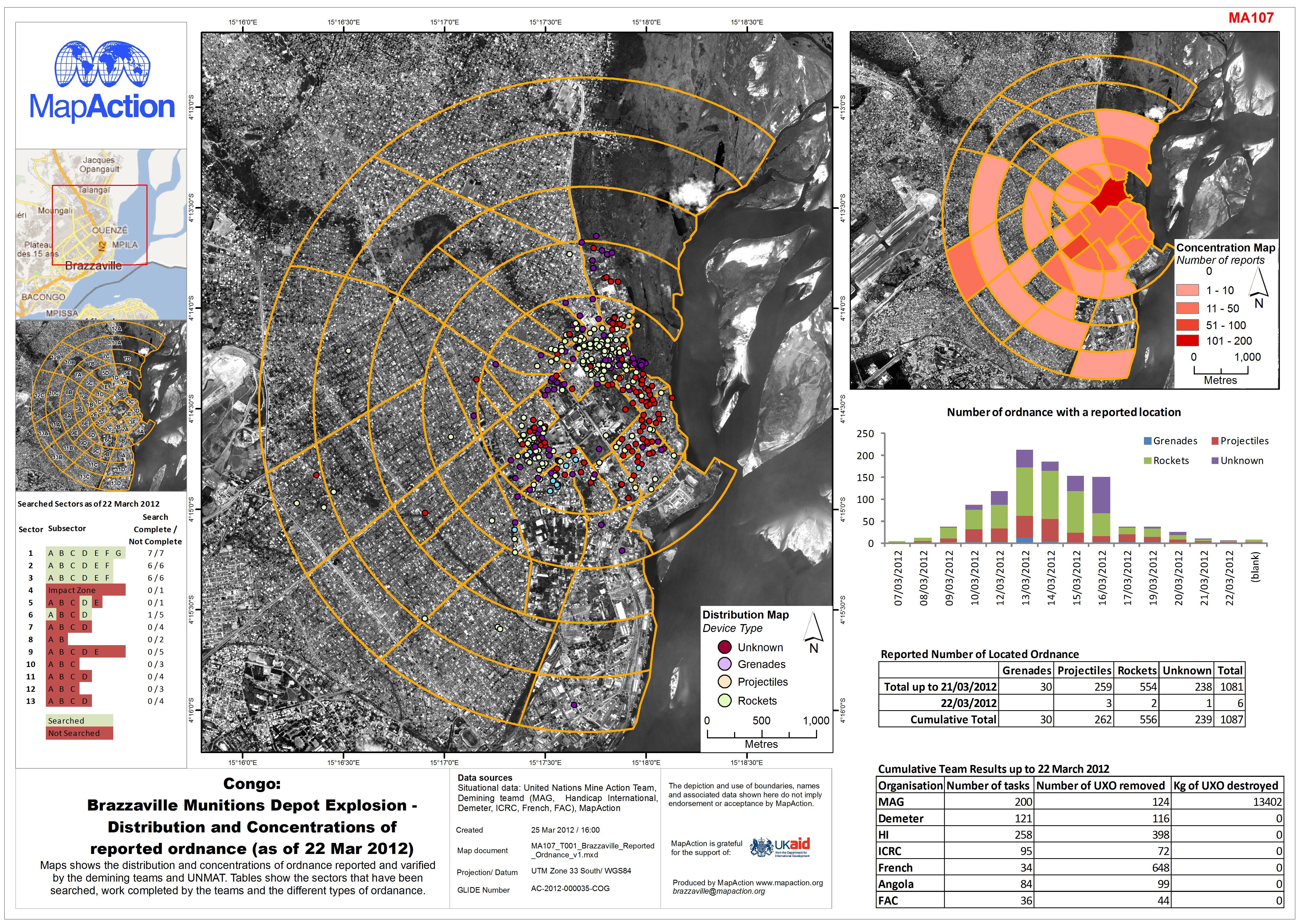
 Congo - Brazzaville Munitions Depot Explosion - Distribution and Concentrations of reported ordnance (as of 22 Mar 2012)
Maps produced to support clearance or other risk mitigation from unexploded ordnance or other explosive remnants of war. This may be due to generalised contamination of an area post-conflict or as a result of a specific explosive accident or deliberate act.
Strategic or operational?
Operational.
Basemap, baseline or situational?
Situational.
When might it be produced?
When there is a risk from unexploded ordnance with a potential humanitarian impact. This may be when humanitarian operations are being undertaken in an area affected by explosive remnants of war, or in the aftermath of a serious accident that may have caused dispersal of dangerous materials. Maps will invariably be produced under guidance from specialist agencies such as demining organisations.
Intended audience
Organisations involved in making an area safe, and humanitarian actors who need to work in an area believed to be affected by unexploded ordnance or other dangerous materials.
Influence on humanitarian decisions
In addition to serving as an information tool for clearance operations, maps may also be important for clarifying which areas are deemed safe, thereby allowing aid agencies to operate.
- Mapping will generally define zones/areas based on assessed hazards, and may split areas into sectors for technical and non-technical search operations. Such sectioning should normally be based on identifiable features on the ground, unless technical experts request otherwise.
- Maps depicting military locations, even former ones, should be created and circulated with due regard to possible government and military sensitivities, which should be discussed with humanitarian coordination actors before publishing any maps.
Data
- Topographic mapping at large scale to identify terrain features. In urban areas, building footprints (e.g. OpenStreetMap data) may be of high importance.
- Data on areas likely to pose high risks of contamination from explosive remnants of war, for example bridges, route choke points and former military defensive positions. Such data should be collected and used with due regard to sensitivities.
- Operational sector and zone perimeter definitions provided by appropriately qualified specialist agencies.